You start the trail with the crunch of desert sand beneath your boots and the dry scent of sun-baked sagebrush in the air. The walls of Bootlegger Canyon rise higher with every step, their rust-colored curves glowing in the morning light. Then, just when the landscape feels endless, the sandstone opens up to reveal Corona Arch. A colossal red sweep of rock perfectly framed against a cobalt Utah sky. It’s the kind of view that stops conversation, and makes you forget for a moment that you are only a few miles from Moab’s main street.
The Corona Arch Trail isn’t just a hike; it’s a pure distillation of what makes Moab magical. Here, slickrock meets sky, and every step feels like a step deeper into the desert’s heartbeat. No entrance gate, no crowds just you, the sandstone, and the echo of your footsteps in a canyon carved by time.
In this complete guide, you’ll find everything you need to make the most of the experience: how to get there from Moab, what to expect along the route, when to go for the best light, what to bring to stay safe and comfortable, and the insider tips locals use to turn a simple outing into a memory that lasts long after the desert dust has settled on your shoes.

Quick Facts: Corona Arch Trail
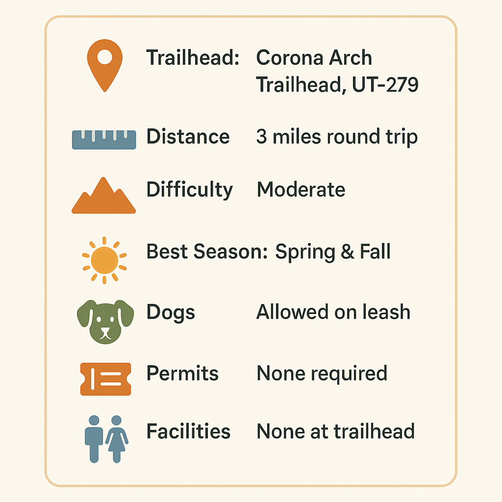
| Detail | Info |
|---|---|
| Location | Potash Road (UT-279), 10 miles west of Moab |
| Trailhead Coordinates | 38.5336° N, 109.6324° W |
| Distance | 3 miles round trip |
| Elevation Gain | 450 feet |
| Difficulty | Moderate |
| Average Time | 1.5–2 hours |
| Dog Friendly | Yes, on leash |
| Fee or Permit | None (BLM Land) |
| Best Seasons | Spring & Fall |
| Trail Type | Out-and-back |
Directions to Corona Arch Trailhead
From downtown Moab, follow these easy directions:
Drive north on US-191 for 4.2 miles.
Turn left onto UT-279 (Potash Road).
Follow Potash Road for about 10 miles until you see a brown BLM sign marked “Corona Arch Trailhead.”
You’ll find a paved lot with restrooms, informational signage, and space for passenger vehicles and RVs. The entire drive hugs the Colorado River, with sheer sandstone cliffs rising hundreds of feet above you. Watch for rock climbers scaling Wall Street, and on the way make a quick stop at the Poison Spider Dinosaur Tracks viewpoint.
Pro Tip: There’s no water at the trailhead. Fill up in Moab before heading out. Gearheads has free filtered water that is fresh and tasty.
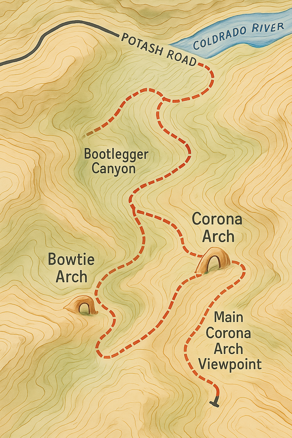
Trail Map & Overview
Trail Summary:
Route Highlights:
0.25 mi: Cross Potash Railroad tracks—great early views.
0.5 mi: Hike up slickrock, following cairns.
1.0 mi: Cable handrail across angled rock; short 6-foot ladder just after.
1.3 mi: Bowtie Arch comes into view on the left.
1.5 mi: Corona Arch dominates the skyline. Relax, explore, and enjoy.
Procal Tips (Pro Tips from Locals)
Go early: Sunrise lights up the arch and keeps you cooler on the way back.
Photography tip: A wide-angle lens captures Bowtie and Corona Arch together. Sunset is dramatic but busier.
Bring snacks: The sandy basin under the arch is perfect for a break.
For kids: The hike is manageable, but expect to help on the cable and ladder sections.
Desert hiking rewards careful preparation and respect for the elements. In this landscape, the sun can be intense, shade is scarce, and the air dries you out faster than you expect. Plan ahead, and the Corona Arch Trail becomes a comfortable, rewarding adventure instead of a challenge. Bring more water than you think you will need because there are no streams, creeks, or trees along the route. Success on Moab’s trails is not about speed or strength but about awareness, pacing, and preparation.
Desert hiking rewards careful preparation and respect for the elements. In this landscape, the sun can be intense, shade is scarce, and the air dries you out faster than you expect. Plan ahead, and the Corona Arch Trail becomes a comfortable, rewarding adventure instead of a challenge. Bring more water than you think you will need because there are no streams, creeks, or trees along the route. Success on Moab’s trails is not about speed or strength but about awareness, pacing, and preparation.
Safety and Trail Etiquette
Corona Arch is moderately challenging but safe for most hikers with basic fitness. Be mindful of heat and exposure.
Safety Reminders
Avoid mid-day summer hikes.
Supervise children on ladder and cable sections.
Keep dogs leashed—there are steep drop-offs near the arch.
Don’t climb or rappel from the arch (this was banned after viral rope-swing videos).
Pack out everything you pack in.
Leave No Trace: Stay on slickrock or sand to protect fragile desert ecosystems.
GPX Waypoints
Trailhead Parking Lot: 38.5794, -109.6321
Railroad Crossing: 38.5799, -109.6332
First Cable Section: 38.5820, -109.6356
Ladder Section: 38.5825, -109.6367
Corona Arch: 38.5837, -109.6393

Best Photo Spots
📸 Under the Arch: Stand back 50 feet to capture its full curve.
🌅 From the Approach Ridge: Great spot for sunset shots with La Sal Mountains on the horizon.
🌌 At Night: On moonless nights, Corona Arch frames the Milky Way perfectly.
Photographer’s Pro Tip: Bring a polarizing filter. The reflected sandstone glare can washout photos.
Nearby Adventures
You’re already on one of Moab’s most scenic roads. Add these stops before or after your hike:
Poison Spider Dinosaur Tracks: 2 miles east on Potash Road; visible fossil prints on a short trail.
Wall Street Climbing Area: Roadside sandstone cliffs popular with rock climbers.
Jug Handle Arch: A quick roadside viewpoint on the same route.
Raft the Colorado River: Book a half-day float at RaftingMoab.com.
Canyoneering Tours: Try U-Turn or Bow & Arrow routes with CanyoneeringMoab.com.
Post-Hike Eats: Refuel at Moab Coffee Roasters or Moab Diner.
FAQs About the Corona Arch Trail
How long does it take to hike the Corona Arch Trail?
Most people finish in 1.5–2 hours round trip, depending on photo stops.
Is Corona Arch better than Delicate Arch?
They’re different experiences—Corona Arch is less crowded, free to access, and just as photogenic.
Can I see Corona Arch without hiking?
No, the arch isn’t visible from Potash Road—you’ll need to hike the 1.5 miles in.
Is it safe for kids or older adults?
Yes, with care. The ladder and cable sections are brief and manageable for most hikers.
Are dogs allowed?
Yes, leashed dogs are welcome. Bring extra water—they’ll need it.
Do I need a permit?
No permit or entrance fee required. The trail sits on Bureau of Land Management land.
Can I camp nearby?
Yes. BLM campgrounds like Jaycee Park, Williams Bottom, and Gold Bar are all along Potash Road.
Plan Your Moab Adventure
The Corona Arch Trail distills what makes Moab unforgettable. Bright red cliffs, wide horizons, and a sense of discovery at every turn. Whether you’re here for a weekend or a week, this trail is one of those hikes that lingers in memory long after you’ve left the desert.
Bring your camera, your curiosity, and your respect for the landscape. Corona Arch will do the rest.
