Moab Rim Hiking Trail – Moab, Utah
A short, steep climb to Moab’s most dramatic views
The Moab Rim Hiking Trail is a powerhouse of a hike. It launches straight up from the Colorado River to a broad slickrock rim where the entire Moab Valley, the La Sal Mountains, and Behind the Rocks open in every direction. Expect a lung buster with a huge payoff.
Quick facts
Location: Kane Creek Blvd, southwest edge of Moab
Distance: 4 miles round trip
Gain: ~1,000 feet in the first mile
Difficulty: Hard
Time: 2.5–4 hours
Best seasons: Spring and fall
Dogs: Yes, on leash
Permits: Not required
Trail description
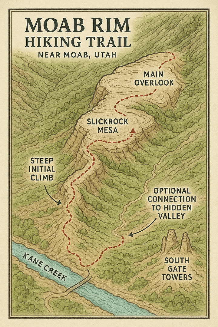
From the trailhead the route climbs immediately on ledgy slickrock shared with an iconic 4×4 track. The grade is relentless and the footing uneven. Views appear almost at once. After about a mile the slope eases onto the rim where cairns lead to several overlooks with the river far below and the La Sals on the skyline. Turn around at the main viewpoint for the classic outing or continue exploring the rim toward Hidden Valley for a bigger day.
Insider tips
Start at sunrise for cooler temps and softer light
Carry more water than you think you need
Wear sticky tread for a controlled descent
Yield to off‑road vehicles on the shared section
Sunset is magic if you bring a headlamp for the way down
Seasonal notes
Spring: Comfortable temps, some wildflowers
Summer: Only at dawn; exposed slickrock can be dangerously hot
Fall: Clear air and ideal hiking weather
Winter: Icy ledges possible; traction helps
Getting there
From downtown Moab, drive south on US‑191, right on Kane Creek Blvd, then about 2 miles to the signed trailhead on the left. Parking is limited. Do not block driveways or the road.
Nearby adventures
Hidden Valley Trail – Quieter slickrock and linkup potential
Amasa Back – Big views on rugged terrain
Kane Creek Petroglyphs – Short stop for rock art
Moab Rim Hiking Trail – FAQ
How hard is the Moab Rim Hiking Trail?
Moab Rim is hard. You gain about 1,000 feet in under a mile on uneven slickrock. Good fitness, sure footing, and plenty of water are essential.
How long does it take to hike the Moab Rim Trail?
Plan 2.5 to 4 hours for the 4 mile round trip, depending on pace, photo stops, and how far you wander along the rim.
Where is the Moab Rim Trailhead?
Along Kane Creek Blvd about 2 miles from downtown Moab. The signed lot is on the left.
Is the Moab Rim Trail dog friendly?
Yes, leashed. Bring extra water and avoid hot slickrock in summer.
What is the best time of year to hike Moab Rim?
Spring and fall. In summer, start at sunrise. In winter, watch for ice.
Plan your hike
Map: Download the printable map from this page before you lose service
Weather: Check today’s Moab hiking weather on our live page.