How to Get to Delicate Arch Trailhead from Moab City Center
If you’re staying in Moab and want to hike the most iconic arch in Utah, this is your complete guide on getting to the Delicate Arch trailhead from Moab. Step by step, with local insight from people who have done the drive plus hike countless times. You’ll learn exactly how long it takes, what route to follow, what to expect at the trailhead, and a few insider tips that make the whole experience smoother.
Why Delicate Arch Is Worth the Drive
Even if you’ve seen photos of Delicate Arch, nothing prepares you for standing beneath it. Rising 46 feet tall and framing the distant La Sal Mountains, this natural sandstone arch has become the symbol of Utah. It is even on the state license plate.
The drive from Moab to the Delicate Arch trailhead is only about 18 miles, but it’s one of the most rewarding short road trips you can take. You’ll pass through the dramatic entrance of Arches National Park, cruise past towering red rock fins, and end up at one of the most photographed spots in the Southwest.
Local Insight: If you want to avoid crowds and catch the best light, plan to start your drive an hour before sunrise or two hours before sunset. The low desert sun turns the arch into a glowing flame.
Overview: The Route at a Glance
Starting Point: Moab City Center (Main Street & Center Street)
Destination: Wolfe Ranch / Delicate Arch Trailhead parking area
Distance: ~18 miles (29 km)
Drive Time: 25–30 minutes
Park Entry Fee: $30 per vehicle (good for 7 days)
Road Type: Fully paved, suitable for all vehicles
Hike Distance from Trailhead: 3 miles round trip
Elevation Gain: ~480 feet
Summary: Getting to the Delicate Arch trailhead from Moab is quick, easy, and absolutely scenic. Just make sure you have plenty of water, park entry fee, and a full tank of gas. Take note, cell service is unreliable inside the park.
Step-by-Step Directions from Moab to Delicate Arch Trailhead
1. Start in Downtown Moab
Begin at the heart of Moab, near the intersection of Main Street (U.S. 191) and Center Street. This is where you’ll find local cafés like Love Muffin Café or Moab Garage Co. — great spots for coffee and breakfast before your hike.
Pro Tip: Eat early. The Delicate Arch parking lot fills fast, especially after 9 AM.
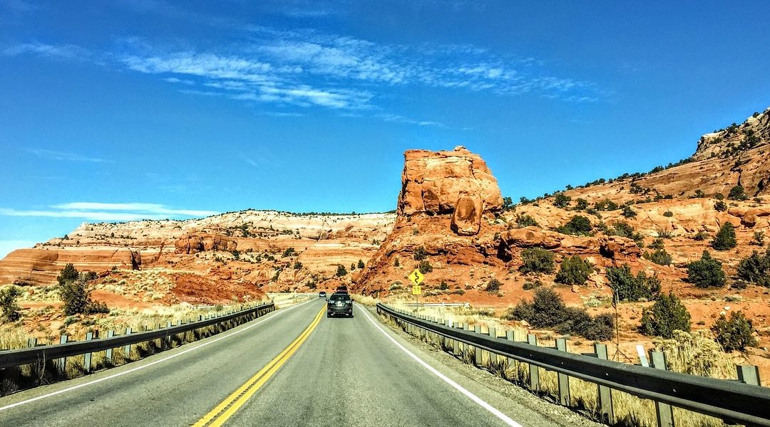
2. Head North on U.S. Highway 191
Drive north out of town on U.S. 191 North. You’ll follow this for about 5 miles (8 km). On your right, you’ll see the red cliffs of Courthouse Wash and the entrance to Arches National Park.
Look for the Arches National Park Entrance Sign — it’s a popular photo stop with the La Sals in the background.
3. Enter Arches National Park
At the entrance station, pay your $30 per vehicle fee (or show your America the Beautiful Pass). Once through the gate, the road begins to climb sharply up a series of switchbacks with incredible views of Moab below.
Distance to Trailhead from Entrance: 12 miles
Estimated Drive Time Inside the Park: 20 minutes
4. Follow Arches Scenic Drive North
Stay on Arches Scenic Drive. You’ll pass several viewpoints and turnouts along the way:
Park Avenue Viewpoint
La Sal Mountains Viewpoint
Balanced Rock
The Windows Section (great for a side trip if you have time)
Keep driving past Balanced Rock, where the road splits. Turn right onto Delicate Arch Road — there’s a clear brown sign marking the turn.
5. Follow Delicate Arch Road to Wolfe Ranch
After turning right, continue 1.2 miles down Delicate Arch Road to reach the Wolfe Ranch Parking Lot, the official Delicate Arch Trailhead.
Coordinates: 38.7350° N, 109.5466° W
Facilities: Restrooms, interpretive signs, limited parking
Trailhead Elevation: 4,300 feet
Parking Tip: The lot often fills between 8 AM and 10 AM. If it’s full, you can park along the road shoulders where permitted. Do not block the roadway or park in vegetation.
What to Expect on the Drive
The route is fully paved and suitable for any type of car, RV, or motorcycle. There are no gas stations inside Arches National Park, so top off your tank before leaving Moab.
Expect a steady climb as you enter the park, followed by gently rolling hills and views of sandstone towers and arches. Cell service is spotty beyond the visitor center, so download your map before you go.
Travel Time in Summer: Up to 45 minutes with entrance lines
Travel Time in Winter: 25 minutes or less
Best Viewpoint En Route: The pullout just past Park Avenue — a perfect first taste of Arches.
Summary: The drive to the Delicate Arch trailhead is short but unforgettable. You’ll experience the full spectrum of Arches’ beauty before your hike even begins.
When to Go
Delicate Arch can be visited year-round, but timing makes a huge difference.
| Season | Drive Conditions | Best Time to Visit |
|---|---|---|
| Spring (Mar–May) | Ideal temps (60s–80s°F); busy | Sunrise or late afternoon |
| Summer (Jun–Aug) | Very hot (90s–100s°F); crowded | Early morning only |
| Fall (Sep–Oct) | Cooler, golden light | Anytime before 4 PM |
| Winter (Nov–Feb) | Quiet, cold mornings | Midday for warmth |
Local Tip: In summer, Arches often implements a timed-entry system. Reserve your entry slot early at recreation.gov.
What to Bring
Even though the drive is short, you’ll be heading deep into desert terrain. Once you park at Wolfe Ranch, there’s no water, shade, or amenities beyond a vault toilet.
Essentials:
2 liters of water per person
National Park Pass or entry receipt
Hat, sunscreen, sunglasses
Camera or phone
Trail snacks and electrolytes
Light layers (especially in spring/fall)
Summary: Think minimal but smart in preparing to visit Arches. Water, sun protection, and a full tank are all non-negotiable.
Quick Map & Route Overview (For PDF or Interactive Map)
Route: Moab City Center → U.S. 191 North → Arches National Park Entrance → Arches Scenic Drive → Delicate Arch Road → Wolfe Ranch
Distance: 18 miles total
Estimated Time: 30 minutes (longer in summer)
Coordinates:
Moab City Center: 38.5733° N, 109.5498° W
Delicate Arch Trailhead: 38.7350° N, 109.5466° W
📍 Driving Tip: Download offline maps in Google Maps before you go. Search “Delicate Arch Trailhead” and tap “Download Offline Map” for the area.
Trailhead Experience
When you arrive at Wolfe Ranch, you’ll find interpretive panels telling the story of the Wolfe family homestead and Ute petroglyphs nearby. Follow the short trail spur to see them before you start your main hike.
The Delicate Arch trail itself begins across the bridge over Salt Wash, then climbs steadily up slickrock toward the arch. You’ll earn the view, but it’s 100% worth it.
Want more details? Read our full guide:
👉 Hike to Delicate Arch: What to Expect, Distance, and Trail Tips
Trail to Table Insight 🍴
After your hike, head back into town for something satisfying — you’ve earned it.
98 Center: Fresh, local Asian-fusion with cold beers and shaded patio seating.
Trailhead Public House: Big burgers and craft brews.
Love Muffin Café: For a second round of espresso and pastries.
You can find more ideas on our sister site EatingMoab.com your insider guide to where to eat in Moab.
FAQs About Directions to Delicate Arch Trailhead from Moab
Q: How far is Delicate Arch trailhead from Moab?
A: It’s about 18 miles one way — roughly a 25–30 minute drive.
Q: Do I need a 4×4 or special vehicle?
A: No. The entire route is paved and suitable for all vehicles, including sedans and RVs.
Q: Is there parking at Delicate Arch trailhead?
A: Yes, but it fills quickly. Arrive before 8 AM or after 4 PM for the best chance.
Q: Can I visit Delicate Arch without hiking?
A: You can see it from Delicate Arch Viewpoint, located just past the main trailhead on the same road — about 1 mile farther.
Q: How early should I leave Moab for sunrise at Delicate Arch?
A: Plan to leave town about 90 minutes before sunrise to allow for park entry, parking, and the 45–60 minute hike up.
Before Leaving for Your Drive to Utah’s Iconic Arch
Driving from Moab to Delicate Arch isn’t just about getting from point A to B it’s part of the adventure. You’ll trace the same route that early explorers, cowboys, and photographers have traveled for decades to witness Utah’s most famous landmark.
Take your time, enjoy the views, and start your hike early. When you finally stand beneath the arch with the desert wind in your ears and the La Sals glowing beyond, you’ll understand why this short drive and hike are so unforgettable.