Fire in Zion What You Must Know (Oct 2025)
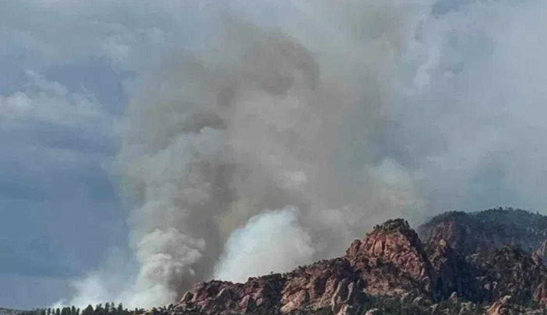
As of October 11, 2025, a 25-acre wildfire is burning in Zion’s West Rim area, triggered by a lightning strike. Trails and roads are already closed (Lava Point, West Rim between Scout Lookout and Lava Point), and smoke is drifting into the canyon’s upper zones.I
Key West Rim Fire Facts (Oct 2025)
| Metric | Status | Notes |
|---|---|---|
| Name / Location | West Rim Fire, Zion NP | Lightning-strike origin National Park Service+2FOX 13 News Utah (KSTU)+2 |
| Size (approx.) | ~ 25 acres | As of latest NPS release National Park Service+1 |
| Closures | Lava Point Road; West Rim Trail between Scout Lookout and Lava Point | National Park Service+2KSL+2 |
| Fire Crews / Resources | 25 wildland firefighters + Type 3 helicopter | The Salt Lake Tribune+3KSL+3National Park Service+3 |
| Smoke / Air Impact | Moderate haze in canyon rims, drifting into mid elevation zones | Reported smoke visible from canyon per press reports E&E News by POLITICO+2FOX 13 News Utah (KSTU)+2 |
| Kolob Side | Still under prior closures from earlier fire in August | Kolob trails & road remain shut from earlier fire event SFGATE+2National Park Service+2 |
Quick take: Zion’s main canyon is still open in many sections, but West Rim is under active closure, and smoke will impact visibility and air quality. If you’re coming from Moab, expect to adapt your plan on the fly.
You Can Still Visit (Carefully)
You might read “fire” and think “don’t go”. However, that is only part of the picture. Zion remains open and some trails in the heart of the canyon are still accessible, rangers are on duty, and for savvy travelers it’s possible to experience incredible scenery while staying safe.
Visiting during this period gives you:
Fewer crowds as some stick to safer zones
Unique smoky-light photography opportunities
A chance to see how dynamic and fragile deserts respond
That said, you have to be flexible , prepared, and self reliant. Smoke, trail closures, and air-quality fluctuations can be a concern.
What to Expect on the Ground: Smoke, Closures & Hazards
Smoke & Air Quality
Reports show visible smoke drifting into Zion’s canyon rims from the West Rim blaze. E&E News by POLITICO+2FOX 13 News Utah (KSTU)+2
Air quality may degrade midday; mornings often clear better.
For those with respiratory sensitivity (asthma, heart conditions), moderate smoke can make strenuous hikes uncomfortable.
Trail & Road Closures
Lava Point Road is closed. National Park Service+2The Salt Lake Tribune+2
The West Rim Trail is closed from Scout Lookout up to Lava Point. The Salt Lake Tribune+3National Park Service+3KSL+3
Kolob side closures are still in effect from earlier fire damage (Kolob Canyons Road, Hop Valley Trail, Taylor Creek, Lee Pass, Timber Creek). Tripadvisor+3SFGATE+3National Park Service+3
Hazards to Watch
Reduced visibility in higher ridge attempts
Heat + smoke combos = greater dehydration
Burned or weakened slopes may shed debris
Downwind shifts can rapidly amplify smoke intrusion
Summary: Your safest bet is to stick to moderate trails in the canyon floor, keep plans short, and monitor conditions constantly.
When Is This Fire Season “Peak”?
Peak Fire Risk Windows
June through early October typically carry the highest fire risk in Zion, due to low humidity and hot temperatures.
Lightning storms in late summer often spark remote ignitions.
Late-season fires (like now) are less common—but still possible.
Safer Visitor Windows
March to May: lower fire danger, greener growth
October to early November: autumn humidity creeps in, still beautiful
Winter: cold, sometimes snowy, but with almost no fire risk
Given this blaze is happening in October, you’re hitting a rare event—but one that underscores the importance of flexibility.
How to Prepare: Gear, Contingencies & Smart Route Selection
Must-Have Gear During Fire Season
N95 or P100 respirator mask (especially if smoke is noticeable)
Clear eye protection (goggles for dust/smoke)
Extra water (heat + smoke dries you faster)
Navigation backup: GPS, offline maps, headlamp
Emergency exit map: know alternate exits out of Zion or toward Moab
Monitoring Tools
Check Zion’s NPS Conditions & Alerts page
Monitor smoke maps on Windy.com
State & federal fire tracking sites (UtahFireInfo)
Sample Routes & Alternatives (from Moab)
| Trail | Difficulty / Length | Fire Risk Comments | Tips / Alternate |
|---|---|---|---|
| Canyon Overlook Trail | Easy (~1 mi round) | Low exposure to fire zones | Good early morning hike |
| Lower Emerald Pools | Moderate (~2–3 mi) | Usually safe unless smoke is heavy | With the bridge reopened, it’s a reliable option |
| The Narrows (bottom-up) | Variable | Risk depends on visibility & water levels | Turn back if smoke becomes thick |
| Angels Landing | Strenuous (~5 mi) | High exposure; avoid if haze is heavy | Skip on smoky days |
| Kolob Side Trails | Varies | Not advisable now — still under closure | Use only if confirmed open |
| Snow Canyon State Park (outside Zion) | Moderate | Likely clearer air, fewer smoke impacts | Great fallback alternative |
If Zion conditions become untenable, Snow Canyon, Cedar Breaks, or mid-elevation trails around Capitol Reef / Arches make excellent pivot options.
Frequently Asked Questions
Q: Is Zion National Park fully closed right now?
A: No. Zion’s main canyon remains accessible in many areas, but West Rim is closed, and some Kolob side trails remain shut. Always check updated alerts.
Q: How bad is the smoke in Zion currently?
A: Smoke is noticeable in the canyon rims, especially midday. Mornings tend to be clearer, but drifting haze is expected.
Q: Can I use campfires or grills inside the park?
A: Zion rescinded Stage 2 fire restrictions on August 29, 2025, returning to its year-round fire rules. National Park Service That means campfires are still only allowed in established rings (Watchman, Lava Point) and only in designated areas.
Q: What trails are definitely closed now?
A: Lava Point Road is closed. West Rim Trail is closed between Scout Lookout and Lava Point. Kolob Canyons Road and connecting trails remain closed from earlier fire damage.
Q: How far is Zion from Moab and does smoke block the drive?
A: Zion is about 280–300 miles, or 4.5–5 hours drive from Moab. Smoke rarely closes highways, but visibility issues can occur. Monitor conditions especially east-to-west roads.
Q: Can I hike around closures?
A: No. Do not bypass closure signs. Burned slopes and weak ground may hide dangers.
Q: When will closed trails reopen?
A: That depends on fire containment, soil stability, and safety inspections. It may take days or even weeks.
Before You Head Out
Visiting Zion right now is more about adaptability than ideal hiking conditions. The fire in Zion National Park (West Rim) is active, closures are in place, and smoke is part of the experience. But for travelers from Moab who know how to pivot, it’s still possible to have a rewarding trip.
If your heart is set on Zion’s iconic trails, plan conservatively, check with rangers, and carry reliable back up. Meanwhile, be sure to have safe alternatives handy (Arches, Canyonlands, or local redrock hikes) in case smoke or closures are in effect.